By Rick Kelson on Nov 04, 2019
3DEP Lidar Proposal for 2020
This article will take 1 minute to read
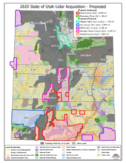
In October a partnership of Utah organizations submitted a proposal to the USGS 3DEP FY19/20 BAA for over 18,217 square miles for 2020 Lidar acquisition projects. A couple projects (i.e., Kane County [Greater Sevier Addition] and Strawberry River) have already begun.
While we’re months away from any preliminary or final funding decisions, the partnership is sharing this proposed project area map in advance in an effort to promote coordination between the partners and avoid duplication of effort in these project areas.
The proposed areas have the following square mileage:

Projects Already Underway
- Kane County (QL2) - 6,055
- Strawberry River (QL1 and 4-band aerial photography) - 88
Proposed Projects
- Wasatch Back (QL1 or QL2) - 1,103
- Iron County (QL1 and QL2) - 3,067
- NRCS (QL1 or QL2) - 2,706
- Sanpete and Sevier Counties (QL2) - 2,397
- Garfield County (QL2) - 2,891
A shapefile of the proposed Lidar coverage areas is available for download.