GIS for 911
Utah Mapping Data and Services in Support of 911 and Emergency Response
A portion of the emergency response (911) - related mapping data and services maintained by UGRC are funded through the State's 911 restricted fund. According to State statute:
53-10-605. (1) Subject to annual legislative appropriation from the fund to: (c) the state's Automated Geographic Reference Center in the Division of Information Technology Services, an amount equal to 1 cent per month levied on telephone services under Section 69-2-5.6 shall be used to enhance and upgrade statewide digital mapping standards.
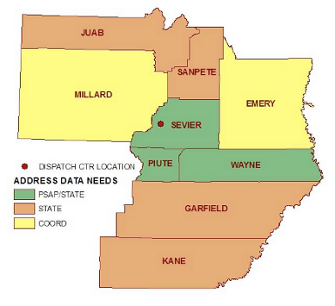
Additionally, State law specifies that the State Geographic Information Database (SGID), managed by UGRC, is the central clearinghouse for geospatial data. The SGID includes road centerline, address data, boundary, ownership, aerial photography, and base map services that are utilized by local, state, federal, and tribal agencies across Utah.
UGRC provides coordination, data integration, and quality assurance to bring local data together and make it functional as a statewide map data layer. Additionally, UGRC staff have provided technical assistance to local PSAPs and jurisdictions in support of improved data resources and technical expertise.
UGRC also participates in the Utah 911 Committee's monthly meetings and stays abreast to GIS-related activities that involve or impact the Public Safety Answering Points (PSAPs) throughout the state. Click here for more information about the Utah 911 Committee.
The following annual reports are based on the State's fiscal years (July 1 to June 30) and summarize UGRC's GIS-related activities in support of local PSAPs and emergency response. Click on a fiscal year to view that year's report: FY12, FY11, FY10, FY09, FY08, FY07, FY06, FY05.