Address Locators
Address Locators
- Category: Address
- Data Type: Geolocators
- Steward(s): UGRC
- Web Application: View
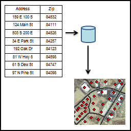
- Abstract: Adding a geographic point for an address is a fundamental GIS task. To handle this task, UGRC has created many services and tools to cater to the wide geocoding user base. Starting from the ground up, UGRC helps maintain statewide address points and roads datasets. These two datasets are the foundation for geocoding. Building on top of the reference data, UGRC creates and maintains ArcGIS Locators. Locators are where most of the magic happens - taking the input data and finding a location from the reference data. These locators are available for download on this page. With the reference data and the locators blocks in place, UGRC can put together geocoding systems and tools. The UGRC WebAPI is a web service that can geocode over the web via http. Users can send requests via their favorite programming language, application, or web browser. This service has some magic to get the best results out of user input and is the recommended way to geocode addresses. UGRC also provide pre-built clients to use the Web API that can be downloaded below. UGRC hopes to have the data and tools ready for your needs to geocode.
UGRC Web API
The UGRC Web API is an http enabeled service for accessing (via the internet) the geospatial data that we store in the State Geographic Information Database (SGID). The endpoints provided by the API are a great way to add geospatial functionality to your web pages and applications or desktop workflows. You will be able to geocode addresses and search all the data in the SGID. To get started, read the getting started guide. There are also examples of geocoding in multiple programming languages.
Related Resources
- Geospatial Web Services
- Using UGRC's Geocoding and Map-based Web Services
- EDG brown bag event presentation
- 2014 UGIC WebAPI Presentation slides
- Rethinking Geocoders: Adding Local Vernacular into the Build Process
- Authoritative Utah Geocoding Results
- Utah Statewide Address Geocoding Web Service Upgrade
Comments, questions, compliments, or concerns can be directed to Steve Gourley from UGRC at SGourley@utah.gov. or the Github repository.
Geocoding Toolbox
This custom toolbox created by the UGRC allows ArcGIS users to geocode a table of addresses. The geocoding tool makes use of the UGRC Web API to perform the geocoding. A complimentary API key will need to be obtained to run the tool.
The tool's documentation is maintained in GitHub. Please refer to the readme for the most current information on downloading and running the tool. ArcGIS Desktop versions of this tool can be found in the py-2 branch.
We've put together a how-to video explaining the basics of using the toolbox.
Related Resources
Comments, questions, compliments, or concerns can be directed to Scott Davis from UGRC at STDavis@utah.gov or the Github repository.
Downloads and Web Services
Updates
- May 2020, Most of the code was modernized and rewritten
- March 2020, The ArcGIS Pro tool was promoted to master
- January 2014, The ArcGIS Desktop tool was created
Roads Address Locator
 AGRC_RoadsLocator is an ArcGIS 10 address locator that references the
statewide Transportation.Roads feature class and uses the right and left
zip code fields and/or the right and left address systems fields for zone.
This address locator is built using an alternate names table, as
recommended in NextGen 911 model. For example, Redwood Road is aliased as
both Highway 68 and 1700 West. Read more about the
underlying data for this locator and how it was created.
AGRC_RoadsLocator is an ArcGIS 10 address locator that references the
statewide Transportation.Roads feature class and uses the right and left
zip code fields and/or the right and left address systems fields for zone.
This address locator is built using an alternate names table, as
recommended in NextGen 911 model. For example, Redwood Road is aliased as
both Highway 68 and 1700 West. Read more about the
underlying data for this locator and how it was created.
Usage
The .gcpk packages are portable files that do not require the
reference data: what is required of the data is included in the packaged.
Once downloaded, Unpack the package and it is ready for use.
You can Unpack the Locator Package in ArcCatalog by
right-clicking on the package. Unpacking will always place the unpacked
locator in your user profile ..\My Documents\ArcGIS\Packages.
Alternately, you can use ESRI's Extract Package tool and
specify an output location. You can also drag the .gcpk file
into ArcMap and it will unpack automatically.
Related Resources
- View recent updates to the SGID Statewide Roads dataset.
-
Download the File Geodatabase
(to build your own locator) that was used to build this address locator.
The dataset contains the roads' alternate names table as well as the
SGID-derived
roads feature class. This table can be joined back to the
GeocodeRoadsfeature class via theGLOBALID_SGIDfield.
Comments, questions, compliments, or concerns can be directed to Greg Bunce from UGRC at GBunce@utah.gov or 801-349-0039.
Downloads and Web Services
Updates
- Updates coincide with SGID Transportation.Roads update. Updates to the Roads are published every month, with approximately nine counties receiving detailed review during each update cycle.
Address Points Address Locator
AGRC_AddressPointLocator is an ArcGIS 10 address locator that references
the statewide Location.AddressPoints feature class and uses zip code
and/or address system for zone. Geocoding match rates will improve as the
Location.AddressPoints feature class continues to be developed.
Usage
The .gcpk packages are portable files that do not require the
reference data: what is required of the data is included in the packaged.
Once downloaded, Unpack the package and it is ready for use.
You can Unpack the Locator Package in ArcCatalog by
right-clicking on the package. Unpacking will always place the unpacked
locator in your user profile ..\My Documents\ArcGIS\Packages.
Alternately, you can use ESRI's Extract Package tool and
specify an output location. You can also drag the .gcpk file
into ArcMap and it will unpack automatically.
Related Resources
-
Download the File Geodatabase
(to build your own locator), which contains the address points'
alternate names table used to build this address locator. This table can
be joined back to the
SgidAddrPntsfeature class via theUTAddPtIDfield.
Comments, questions, compliments, or concerns can be directed to Greg Bunce from UGRC at GBunce@utah.gov or 801-349-0039.
Downloads and Web Services
Updates
- Updates coincide with SGID Location.AddressPoints updates. Updates to the Address Points are published every month.
Composite Address Locator
AGRC_CompositeLocator is an ArcGIS 10 composite address locator built from
the AGRC_AddressPointLocator and the AGRC_RoadsLocator locators and uses
zip code and/or address system for zone. These locators reference the
Transportation.Roads and Location.AddressPoints feature classes.
Usage
The .gcpk packages are portable files that do not require the
reference data: what is required of the data is included in the packaged.
Once downloaded, Unpack the package and it is ready for use.
You can Unpack the Locator Package in ArcCatalog by
right-clicking on the package. Unpacking will always place the unpacked
locator in your user profile ..\My Documents\ArcGIS\Packages.
Alternately, you can use ESRI's Extract Package tool and
specify an output location. You can also drag the .gcpk file
into ArcMap and it will unpack automatically.
Comments, questions, compliments, or concerns can be directed to Greg Bunce from UGRC at GBunce@utah.gov or 801-349-0039.
Downloads and Web Services
Updates
- Updates to this composite locator coincide with the Roads and Address Points address locators.