National Agricultural Imagery Program
NAIP
- Category: Aerial-photography
- Data Type: Imagery
- Steward(s): UGRC
- Web Application: View
- Abstract: National Agricultural Imagery Program is color aerial photography typically collected every 2 or 3 years in the middle of the summer. Starting in 2006 the acquisitions have been statewide. The resolution is usually 1 meter with a horizontal positional accuracy of -/+ 5 meters. The 2018 & 2021 imagery is .6 meter (60 centimeter) resolution with a horizontal positional accuracy of -/+ 4 meters. For more information about the history of the NAIP collections take a look at this Map Tour from the USDA or visit their NAIP GeoHub.
2021
UGRC has the preliminary statewide
National Agricultural Imagery Program
(NAIP) 3-band aerial photography for Utah in Mr. Sid county mosaics.
The imagery is .6-meter (60 centimeter) resolution and was collected in the summer and fall of 2021.
The date the photography was flown can be found in the IDATE field in the associated shapefile.
Be aware some of the larger counties (ex. San Juan, Millard, Tooele and Box Elder) are no longer split
into multiple parts and their file size is upwards of 4 to 7 GB. The images have a UTM NAD83 meters projection.
Downloads
Related Resources
- If you are having problems with the imagery from UGRC, read this document before contacting us.
Comments, questions, compliments, or concerns can be directed to Rick Kelson from UGRC at RKelson@utah.gov.
2018
UGRC has statewide National
Agricultural Imagery Program (NAIP) aerial photography for Utah. The imagery is .6 meter (60 centimeter)
resolution and was collected in the summer of 2018. Although the NAIP imagery collection is typically 4-band
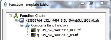
imagery, we have separated the Red, Green, and Blue bands from the Infrared band. To merge the RGB images with the
single infrared band to create a 4-band image you can use the ArcGIS Composite Bands (Data Management) tool, the
Image Analysis window to add a Function Chain, or
create a Reference Mosaic. 3-band Mr. Sid RGB and CIR (NIR-R-G) county
mosaics are also available.
The date the photography was flown can be found in the SrcImgDate field of the NAIP2018
Index shapefile, in the .txt metadata files after Calendar_Date, or the
SDATE field of the county mosaics shapefile. The images have a UTM NAD83 meters projection.
Downloads
Related Resources
- If you are having problems with the imagery from UGRC, read this document before contacting us.
Comments, questions, compliments, or concerns can be directed to Rick Kelson from UGRC at RKelson@utah.gov.
2016
UGRC has statewide National
Agricultural Imagery Program (NAIP) aerial photography for Utah. The imagery is 1-meter resolution and was
collected in the summer of 2016. Although the NAIP imagery collection is typically 4-band imagery, we have
separated the Red, Green, and Blue bands from the Infrared band. To merge the RGB images with the single infrared
band to create a 4-band image you can use the ArcGIS Composite Bands (Data Management) tool, the Image Analysis
window to add a Function Chain, or create a Reference Mosaic. 3-band Mr. Sid county mosaics are also
available.
The date the photography was flown can be found in the SrcImgDate field of the NAIP2016
Index shapefile, in the .txt metadata files after Calendar_Date, or the
SDATE field of the county mosaics shapefile. The images have a UTM NAD83 meters projection.
Downloads
Related Resources
- If you are having problems with the imagery from UGRC, read this document before contacting us.
Comments, questions, compliments, or concerns can be directed to Rick Kelson from UGRC at RKelson@utah.gov.
2014
UGRC has statewide National Agricultural Imagery Program (NAIP) aerial photography for Utah. The imagery is 1-meter resolution and was collected in the summer of 2014. Although the NAIP imagery collection is typically 4-band imagery, we have separated the Red, Green, and Blue bands from the Infrared band. To merge the RGB images with the single infrared band to create a 4-band image you can use the ArcGIS Composite Bands (Data Management) tool, the Image Analysis window to add a Function Chain, or create a Reference Mosaic.
The date the photography was flown can be found in the SrcImgDate field of the NAIP2014
Index shapefile, in the .txt metadata files after Calendar_Date, or the
SDATE field of the county mosaics shapefile. The images have a UTM NAD83 meters projection.
The USDA also has the NAIP imagery available as a 4-band service for all the states in the U.S. The available
GIS Service URL is
https://gis.apfo.usda.gov/arcgis/rest/services/NAIP.
Downloads
Related Resources
- If you are having problems with the imagery from UGRC, read this document before contacting us.
Comments, questions, compliments, or concerns can be directed to Rick Kelson from UGRC at RKelson@utah.gov.
2011
UGRC has statewide National
Agricultural Imagery Program (NAIP) 4-band aerial photography for Utah. The imagery is 1-meter resolution
and was collected in the summer of 2011. The date the photography was flown can be found in the
SrcAImgDate field of the NAIP2011_4-band_Index
shapefile, the IDATE field in the NAIP2011_4-band_FlightDate_Index
shapefile, in the .txt metadata files after Calendar_Date, or the SDATE field of the
county mosaics shapefile. The images have a UTM NAD83 meters projection.
Downloads
Related Resources
- If you are having problems with the imagery from UGRC, read this document before contacting us.
Comments, questions, compliments, or concerns can be directed to Rick Kelson from UGRC at RKelson@utah.gov.
2009
UGRC has statewide National Agricultural Imagery Program (NAIP) natural color aerial photography for Utah. The
imagery is 1-meter resolution and was collected in the summer of 2009. The date the photography was flown can be
found in the SrcImgDate field of the NAIP2009
Index shapefile for the individual .tiff files or the SDATE field of the county
mosaics index file. The images have a UTM NAD83 meters projection.
Downloads
Related Resources
- If you are having problems with the imagery from UGRC, read this document before contacting us.
Comments, questions, compliments, or concerns can be directed to Rick Kelson from UGRC at RKelson@utah.gov.
2006 and Older
UGRC has National Agricultural Imagery Program (NAIP) natural color aerial photography for many of the
agricultural areas of Utah in 2-meter resolution for 2003 and 1-meter resolution for 2004 and 2006. The 2006 NAIP
is a statewide coverage. The images are grouped together by county. They can be downloaded as a .zip
file. The .zip file contains a compressed .sid Mr.Sid image. When adding the image to a
View or Data Frame, add the .sid file and not the associated bands. The date the photography was
flown for 2003 can be found in the .txt file of county mosaic. For 2004 the date is in the
IDAT field of the compressed county mosaic index. For the 2006 imagery the NAIP2006
Index shapefile or the .txt file of the associated image quarter quad .tif image
tile contain the date the image was flown. The images have a UTM NAD83 meters projection.
Downloads
Related Resources
- If you are having problems with the imagery from UGRC, read this document before contacting us.
Comments, questions, compliments, or concerns can be directed to Rick Kelson from UGRC at RKelson@utah.gov.