Utah Parcel Data
- Category: Cadastre
- Data Type: GIS Data Layer
- Steward(s): UGRC and Local Government
- Web Application: View
- Abstract: Parcel data contains GIS mapping data representing parcel boundaries. UGRC has parcel data for all 29 counties. Some
counties are more complete than others. In addition to the polygon geometry the attributes
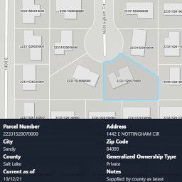
PARCEL ID,PARCEL ADDRESS,PARCELS CITY,PARCEL ZIP CODE,OWNERSHIP TYPE, andRECORDERcontact are maintained in the Basic Parcel dataset when available. Users should be aware the owner type fieldOWN_TYPEin the parcel polygons is a very generalized ownership type (Federal, Private, State, Tribal). It is populated with the value of theOWNERfield where the parcel's centroid intersects the Land Ownership polygon layer.
While addresses are provided with the parcel boundaries the authoritative dataset for addresses from UGRC is the Address Points layer.
Utah Basic Parcels

Parcels_{County name} are datasets for cartography and approximate boundary identification.
In 2005, HB113 was passed requiring the UGRC Cadastral Surveyor to work with local government to create a parcel database for the State.
63F-1-506.(3) (c) coordinate with county recorders and surveyors to create a statewide parcel layer in the State Geographic Information Database (SGID) containing parcel boundary, parcel identifier, parcel address, owner type, and county recorder contact information.
The SGID contains county parcel data for each of the 29 counties in Utah and is updated as new data is provided from the data steward in each county. A statewide parcel dataset is available from AGOL and UGRC Open Data site in addition to vector tiles with labels and without labels.
Parcel polygons contain attributes unique to each parcel such as a unique parcel number (PARCEL_ID),
address for the parcel (PARCEL_ADD, PARCEL_CITY, PARCEL_ZIP), update
information (ParcelsCur, ParcelsRec, ParcelsPub, ParcelYear,
ParcelNotes), a generalized land ownership designation (OWN_TYPE), and the phone number
for the county recorders office (RECORDER).
This data when possible is updated twice a year with the newest data available from the counties. Some counties along the Wasatch Front are updated monthly when possible.
There are no constraints or warranties with regard to the use of this dataset. Users are encouraged to attribute content to: State of Utah, SGID.
Comments, questions, compliments, or concerns can be directed to Rick Kelson from UGRC at RKelson@utah.gov.
Downloads
Updates
- March 2022 - Davis, Kane, Utah, Washington, Weber
- February 2022 - Davis, Grand, Kane, Summit, Utah, Wasatch, Washington, Weber
- January 2022 - Davis, Millard, Rich, Utah, Washington, Weber
- December 2021 - Davis, Salt Lake, Tooele, Utah, Washington, Weber
- November 2021 - Carbon, Davis, Kane, Utah, Washington, Weber
- October 2021 - Davis, Kane, Salt Lake, Tooele, Utah, Washington, Weber
- September 2021 - Cache, Davis, Grand, Kane, Morgan, Salt Lake, Summit, Utah, Wasatch, Washington, Weber
- August 2021 - Carbon, Davis, Kane, Millard, Utah, Washington, Weber
- July 2021 - Beaver, Emery, Davis, Salt Lake, Utah, Washington, Weber
- June 2021 - Daggett, Davis, Kane, Utah, Washington, Weber
- May 2021 - Davis, Kane, Piute, Salt Lake, Utah, Washington, Weber
- April 2021 - Box Elder, Davis, Garfield, Iron, Kane, Utah, Washington, Weber
- March 2021 - Carbon, Davis, Salt Lake, Utah, Washington, Weber
- February 2021 - Davis, Grand, Summit, Utah, Washington, Weber
- January 2021 - Davis, Salt Lake, Utah, Washington, Weber
- December 2020 - Davis, Kane, Salt Lake, Utah, Washington, Weber
- November 2020 - Davis, Utah, Washington, Weber
- October 2020 - Davis, Iron, Morgan, Salt Lake, Summit, Tooele, Utah, Washington, Weber
- September 2020 - Box Elder, Carbon, Davis, Millard, Utah, Wasatch, Washington, Weber
- August 2020 - Box Elder, Cache, Carbon, Grand, Salt Lake, Utah, Washington, Weber
- July 2020 - Beaver, Davis, Emery, Salt Lake, Utah, Washington, Weber
- June 2020 - Daggett, Davis, Salt Lake, Utah, Washington, Weber
- May 2020 - Box Elder, Davis, Iron, Kane, Rich, Salt Lake, Uintah, Utah, Washington, Weber
- March 2020 - Davis, Garfield, Piute, Tooele, Utah, Washington, Weber
- February 2020 - Davis, Grand, Kane, Salt Lake, Summit, Utah, Washington, Weber
- January 2020 - Davis, Utah, Wasatch, Washington, Weber
- December 2019 - Davis, Morgan, Salt Lake, Summit, Utah, Washington, Weber
- November 2019 - Davis, Rich, Salt Lake, Tooele, Utah, Washington, Weber
- October 2019 - Carbon, Morgan, Salt Lake, Utah, Washington, Weber
- September 2019 - Davis, Cache, Salt Lake, Tooele, Utah, Washington, Weber
- August 2019 - Daggett, Davis, Iron, Salt Lake, Summit, Utah, Washington, Weber
- July 2019 - Beaver, Box Elder, Cache, Davis, Emery, Kane, Millard, Salt Lake, Utah, Wasatch, Washington, Weber
- June 2019 - Daggett, Davis, Salt Lake, Tooele, Utah, Washington, Weber
- May 2019 - Davis, Iron, Salt Lake, Utah, Washington, Weber
- April 2019 - Box Elder, Salt Lake, Utah, Wasatch, Washington, Weber
- March 2019 - Cache, Davis, Duchesne, Piute, Salt Lake, Tooele, Washington, Weber, Utah
- February 2019 - Davis, Kane, Rich, Salt Lake, Washington, Utah
- January 2019 - Salt Lake, Summit, Uintah, Utah, Washington, Weber
- December 2018 - Davis, Morgan, Rich, Salt Lake, Utah, Washington, Weber
- November 2018 - Davis, Juab, Salt Lake, Utah, Washington
- October 2018 - Box Elder, Iron, Morgan, Salt Lake, Summit, Tooele, Utah, Washington, Weber
- September 2018 - Cache, Daggett, Davis, Grand, Rich, Tooele, Utah, Washington, Weber
- August 2018 - Box Elder, Cache, Carbon, Davis, Salt Lake, Utah, Wasatch, Washington
- July 2018 - Beaver, Davis, Emery, Kane, Salt Lake, Utah, Washington, Weber
- June 2018 - Daggett, Davis, Morgan, Iron, Salt Lake, Utah, Washington
- May 2018 - Davis, Salt Lake, Tooele, Utah, Wasatch, Washington, Weber
- April 2018 - Salt Lake, Utah, Washington
- March 2018 - Box Elder, Davis, Morgan, Salt Lake, Utah, Washington, Weber
- February 2018 - Cache, Davis, Garfield, Piute, Salt Lake, Summit, Tooele, Utah, Washington, Wasatch, Weber
- January 2018 - Salt Lake, Utah, Washington
Utah Land Information Record Parcels
Parcels_{County name}_LIR are datasets for cartography and approximate boundary identification.
The Land Information Record Parcels (LIR) contain GIS mapping data representing parcel boundaries and county tax roll attributes. UGRC has Land Information Record Parcels for some of the counties in Utah. Since each County has its own database and process for maintaining tax year assessment information, users should expect some variability in each County's LIR dataset.
In addition to the polygon geometry the attributes COUNTY_NAME, COUNTY_ID,
ASSESSOR_SRC, BOUNDARY_SRC, DISCLAIMER, CURRENT_ASOF,
PARCEL_ID, SERIAL_NUM, PARCEL_ADD, PARCEL_CITY,
TAXEXEMPT_TYPE, TAX_DISTRICT, TOTAL_MKT_VALUE, LAND_MKT_VALUE,
PARCEL_ACRES, PROP_CLASS, PRIMARY_RES, HOUSE_CNT,
SUBDIV_NAME, BLDG_SQFT, BLDG_SQFT_INFO, FLOORS_CNT,
FLOORS_INFO, BUILT_YR, EFFBUILT_YR, CONST_MATERIAL are
maintained in the Land Information Record Parcels dataset when available.
The Land Information Records (LIR) work group organized by the Governor’s Office of Management and Budget has facilitated a voluntary sharing of tax roll parcel data from County Assessors to support public safety, economic development, transportation, planning and the provisions of public services. In May of 2016, the Land Information Records work group released its recommendations for sharing an enhanced set of tax parcel GIS data. A draft of the tax year parcel GIS data schema is available.
Tax year parcel GIS data will be updated annually with the finalized year-end tax assessment data that is completed by May 22nd each year then submitted to the Utah Geospatial Resource Center (UGRC) for loading into SDE by July 1st each year.
There are no constraints or warranties with regard to the use of this dataset. Users are encouraged to attribute content to: State of Utah, SGID.
Comments, questions, compliments, or concerns can be directed to Rick Kelson from UGRC at RKelson@utah.gov.
Downloads
Reference the table above.
Updates
This data, when possible, is updated annually.