Wasatch Front LiDAR Elevation Data
Wasatch Front LiDAR Elevation Data
- Category: Elevation-and-terrain
- Data Type: LiDAR in img format
- Steward(s): UGRC
- Web Application: View
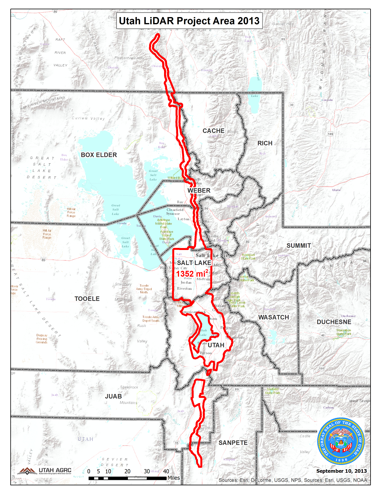
- Abstract: During the Fall of 2013 and the Spring of 2014 UGRC and partners acquired 1,422 square miles of 8 points per meter Quality Level 1 LiDAR for areas along the Wasatch Front including the urbanized areas of Salt Lake County and Utah County and areas along the Wasatch Fault from Sanpete County north into Oneida County in southeast Idaho. The .5 meter resolution bare earth hydro flattened DTMs and first-return/highest-hit DSMs in .img format have a 9.25cm vertical RMSE accuracy. The LAS classified point clouds are also available by contacting Rick Kelson from UGRC at RKelson@utah.gov or from Open Topography. This elevation data has a UTM NAD83 (2011) zone 12 north meters NAVD88(GEOID12) projection.
Elevation Data
The 2013-2014 bare earth DTMs and first return DSMs are available for download via the raster.utah.gov interactive map. All of the 2013-2014 products are available from the Open Topography interactive map. The naming convention for the tiles are based off the U.S. National Grid (USNG). Utah is distributed over the USNG grid zone 12T and 12S.
If you are a CAD or Microstation user you may need to convert the .img files into a
different file format such as .las. My suggestion is to search the internet for
AutoCad and .img or search the user forums. There are discussions about converting the files from
.img format to a format you can use. There is different software, many free (FW Tools, ER Viewer),
that can convert the .img files to whatever flavor your software needs. GIS software like ArcMap can
convert the files too. The trial version of Global Mapper can also convert the files. You can also be download the
LAS point clouds from Open
Topography.
Related Resources
- Project Reports and Metadata
- Shapefiles of the project area, tile indices, and breaklines.
- LiDAR derivative samples (1GB file) [ArcMap , CAD]
- For more information about LiDAR visit Exploring LiDAR
Comments, questions, compliments, or concerns can be directed to Rick Kelson from UGRC at RKelson@utah.gov.
Downloads and Web Services
Updates
- 2014
Examples
DTM
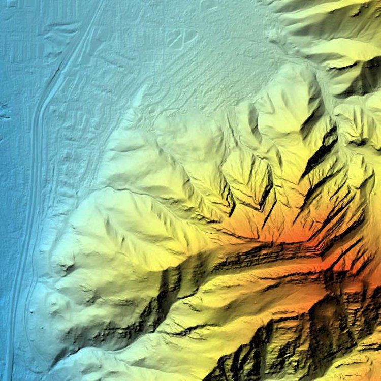
A Digital Terrain Model (DTM), commonly referred to as a DEM, is a digital file consisting of terrain elevations for ground positions at regularly spaced horizontal intervals. In this dataset features above the ground such as buildings and trees have been removed from the elevation model. The resolution of this data is .5 Meter and is sufficient for generating 1 foot contours. This data has a wide range of applications and is most commonly used in flood and hydro-logic modeling, geologic hazard mapping, contour line creation, and rectification of aerial photography and satellite imagery.
DSM
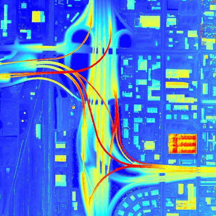
A Digital Surface Model (DSM) is similar to a DTM but features above the ground terrain have not been removed from the elevation model. The resolution of this data is .5 Meter. This data has a wide range of applications including analyzing solar potential, vegetation quantification, and building or surface feature delineation.
LiDAR Point Cloud
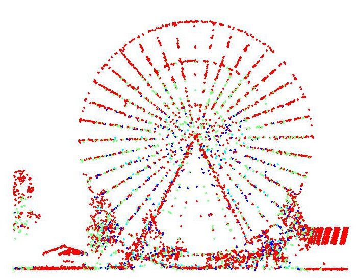
LiDAR is collected with laser pulses that return to the sensor and are stored as a point cloud. Each point in the cloud can be assigned an X,Y,Z, intensity, return number, RGB value etc. Each LiDAR point can also have classifications for landcover types (ex. ground, water, road, building, vegetation, etc.). The LAS point cloud files associated with this project have the following classifications yet further classification of the point cloud is possible:
| Code | Description |
|---|---|
| 1 | Processed, but unclassified |
| 2 | Bare-earth ground |
| 7 | Noise |
| 9 | Water |
| 10 | Ignored Ground (Breakline proximity) |
| 11 | Withheld |