2020 Southern Utah Lidar Elevation Data
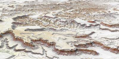
 During 2020 UGRC and the Utah Division of Emergency Management acquired ~9,740 square miles of 2 and 8 points per meter Quality Level 1 & 2 LiDAR of portions of Southern Utah. The .5 and 1 meter resolution bare earth DEMs and first-return/highest-hit DSMs in .tif format have a 10.0cm vertical RMSE accuracy and are available for download. The LAS point clouds are available from The National Map or by request from Rick Kelson from UGRC at RKelson@utah.gov. This elevation data was collected between May and July, 2020.
- Retrieve 2020 Bare Earth DTMs and First Return DSMs via Interactive Map
- Download project Reports and Metadata
- Download shapefiles of project area, tile indices, and breaklines
The naming convention for the tiles are based off the U.S. National Grid (USNG).
This elevation data has a UTM NAD83 (2011) zone 12 north meters NAVD88(GEOID12) projection with the exception of a small strip on the western edge of the project area in zone 11.
Comments, questions, compliments, or concerns can be directed to Rick Kelson from UGRC at RKelson@utah.gov.