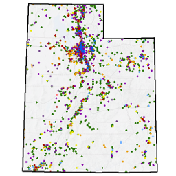
DEQ Land-Related Contaminant and Cleanup Data
- Category: Environment
- Data Type: GIS Data Layer
- Steward(s): Utah Department of Environmental Quality
- Web Application: View
- Abstract: US EPA and State designated hazardous materials storage sites and contamination clean up program sites including CERLA, National Priority List, Underground Storage Tanks (UST), Brownfields, Voluntary Cleanup (VCP), Tier 2, Toxic Release Inventory (TRI), User Oil Permitted Facilities, Formerly Used Defense (FUD), RCRA Large & Small Quantity Hazardous Waste Generators, Solid Waste Facilities, and Enforceable Written Assurance sites. To view all DEQ geographic data online, see the DEQ Interactive Map Viewer.
Brownfields Targeted for Cleanup

Utah DEQ Brownfields Targeted contains the coordinates of Brownfields Projects targeted for cleanup. These locations were derived from maps and GPS data and represent sites, not contaminated areas. Brownfields are real property, the expansion, redevelopment, or reuse of which may be complicated by the presence or potential presence of a hazardous substance, pollutant, or contaminant. Cleaning up and reinvesting in these properties takes development pressures off of undeveloped open land, and both improves and protects the environment. For more information see: https://www.epa.gov/brownfields/.
Comments, questions, compliments, or concerns can be directed to Bill Rees from DEQ at BRees@utah.gov or 801-536-4167.
Related Resources
Downloads and Web Services
Updates
- Nightly
Brownfields Not Targeted For Cleanup

Utah DEQ Brownfields Other contains the coordinates of Brownfields Projects not targeted for cleanup. These locations represent sites, not contaminated areas, and were derived from maps and GPS data. For more information see: https://www.epa.gov/brownfields/
Comments, questions, compliments, or concerns can be directed to Bill Rees from DEQ at BRees@utah.gov or 801-536-4167.
Related Resources
Downloads and Web Services
Updates
- Nightly
Hazardous Waste and Used Oil Facilities

Utah DWMRC Hazardous Waste and Used Oil Facilities contains sites that generate hazardous waste; that treat, store, or dispose of hazardous waste; and sites that transport, market, or recycle used oil.
Comments, questions, compliments, or concerns can be directed to Thomas Ball from DEQ at TBall@utah.gov or 801-536-0251.
Related Resources
Downloads and Web Services
Updates
- Nightly
Low Level Waste Disposal and Uranium Mills

Utah DWMRC Low Level Waste Disposal and Uranium Mill Facilities contains sites that treat or dispose of radioactive waste or process uranium ore.
Comments, questions, compliments, or concerns can be directed to Thomas Ball from DEQ at TBall@utah.gov or 801-536-0251.
Related Resources
Downloads and Web Services
Updates
- Nightly
Solid Waste Landfills

Utah DWMRC Solid Waste Facilities contains locations for open and closed Solid Waste Landfills in Utah.
Comments, questions, compliments, or concerns can be directed to Thomas Ball from DEQ at TBall@utah.gov or 801-536-0251.
Related Resources
Downloads and Web Services
Updates
- Nightly
Formerly Used Defense Sites (FUDS)

Utah DEQ Formerly Used Defense contains locations of potential Formerly Used Defense sites. The Department of Defense (DoD) is responsible for environmental restoration of FUDS. FUD locations are based on coordinates derived from maps and GPS data. These locations represent sites, not contaminated areas.
Comments, questions, compliments, or concerns can be directed to Michael Storck from DEQ at MStorck@utah.gov or 801-536-4179.
Related Resources
Downloads and Web Services
Updates
- Nightly
Military Munitions Response Program (MMRP)

Utah DEQ Military Munition Response Program contains locations of Military Munitions Response Program sites. MMRP manages the environmental, health and safety issues presented by unexploded ordnances (UXO), discarded military munitions (DMM) and munitions constituents (MC). Locations are based on coordinates derived from maps and GPS data. These locations represent sites, not contaminated areas.
Comments, questions, compliments, or concerns can be directed to Michael Storck from DEQ at MStorck@utah.gov or 801-536-4179.
Related Resources
Downloads and Web Services
Updates
- Nightly
Enforceable Written Assurances (EWA)

Utah DEQ Enforceable Written Assurances contains locations of potential Enforceable Written Assurance sites. EWAs will generally ensure to property owners or prospective property owners that there is no unacceptable risk to human health or the environment. EWA locations are based on coordinates derived from maps and GPS data. These locations represent sites, not contaminated areas.
Comments, questions, compliments, or concerns can be directed to Bill Rees from DEQ at BRees@utah.gov or 801-536-4167.
Related Resources
Downloads and Web Services
Updates
- Nightly
National Priorities List (NPL)

Utah DEQ CERCLA National Priorities List contains locations of Utah National Priorities List Sites. The NPL is the list of national priorities among the known releases or threatened releases of hazardous substances, pollutants, or contaminants throughout the United States. Locations are based on coordinates derived from maps and GPS data. These locations represent sites, not contaminated areas.
Comments, questions, compliments, or concerns can be directed to Michelle Horning from DEQ at mhorning@utah.gov or 801-536-4128.
Related Resources
Downloads and Web Services
Updates
- Nightly
Superfund Sites

Utah DEQ CERCLA CERCLIS List contains locations of potential EPA Superfund sites. The Comprehensive Environmental Response, Compensation, and Liability Act (CERCLA), commonly known as Superfund, imposes a tax on the chemical and petroleum industries and provides Federal authority to respond directly to releases or threatened releases of hazardous substances that may endanger public health or the environment. Locations are based on coordinates derived from maps and GPS data. These locations represent sites, not contaminated areas.
Comments, questions, compliments, or concerns can be directed to Michelle Horning from DEQ at mhorning@utah.gov or 801-536-4128.
Related Resources
Downloads and Web Services
Updates
- Nightly
Institutional Control Buffer Zones

Utah DEQ Environmental Covenant Buffer Zones contains Institutional Control Buffer Zones in Utah.
Related Resources
Downloads and Web Services
Updates
- Nightly
Utah Toxic Release Inventory Tier II

Utah DEQ TIER2 contains locations of Tier II facilities under the Emergency Planning and Community Right-to-Know Act (EPCRA). Qualifying facilities report on hazardous and toxic chemicals and are labeled either tier I or tier II. Locations are based on coordinates derived from maps and GPS data. These locations represent sites, not contaminated areas. The areas of contamination will be identified at a later stage.
Comments, questions, compliments, or concerns can be directed to Michelle Horning from DEQ at mhorning@utah.gov or 801-536-4128.
Related Resources
Downloads and Web Services
Updates
- Nightly
Toxic Release Inventory (TRI)

Utah DEQ Toxic Release Inventory contains TRI locations in Utah. TRI is an EPA database containing data on disposal or release of toxic chemicals from U.S. facilities and information about how facilities manage those chemicals through recycling, energy recovery, and treatment. Locations are based on coordinates derived from maps and GPS data. These locations represent sites, not contaminated areas. The areas of contamination will be identified at a later stage.
Comments, questions, compliments, or concerns can be directed to Michelle Horning from DEQ at mhorning@utah.gov or 801-536-4128.
Related Resources
Downloads and Web Services
Updates
- Nightly
Voluntary Cleanup Program (VCP)

Utah DEQ Voluntary Cleanup Program contains locations of Utah VCP. VCP is a program to encourage the voluntary cleanup of sites where there has been a contaminant release threatening public health and the environment. Locations are based on coordinates derived from maps and GPS data. These locations represent sites, not contaminated areas.
Comments, questions, compliments, or concerns can be directed to Bill Rees from DEQ at BRees@utah.gov or 801-536-4167.
Related Resources
Downloads and Web Services
Updates
- Nightly
FacilityUST

Utah DEQ Underground Storage Tanks contains the locations of facilities with underground storage tanks.
Comments, questions, compliments, or concerns can be directed to Michelle Horning from DEQ at mhorning@utah.gov or 801-536-4128.
Related Resources
Downloads and Web Services
Updates
- Nightly