Aquifers
- Category: Geoscience
- Data Type: GIS Data Layer
- Steward(s): UGRC, USGS, and DEQ
- Abstract: The Aquifers data contains the Recharge Discharge Areas and the Basin Fill Boundaries along the Wasatch Front and adjacent areas.
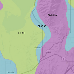
Recharge Discharge Areas

Aquifer Recharge Discharge Areas contains the recharge and discharge areas of the principal aquifers along the Wasatch Front and adjacent areas.
Related Resources
Comments, questions, compliments, or concerns can be directed to Diedre Beck from DEQ at DBeck@utah.gov or 801-536-4201.
Downloads and Web Services
Updates
- May 2016
Basin Fill Boundary

Aquifer Basin Fill Boundary contains the approximate boundaries of basin fill in ground-water recharge and discharge areas of the principal aquifers along the Wasatch Front and adjacent areas.
Related Resources
Comments, questions, compliments, or concerns can be directed to Diedre Beck from DEQ at DBeck@utah.gov or 801-536-4201.
Downloads and Web Services
Updates
- August 2011