Water Related Land Use
- Category: Planning
- Data Type: GIS Data Layer
- Steward(s): DNR
- Abstract: Water usage-related polygon map data, published annually by the Utah Division of Water Resources at DNR that depicts the types and extent of irrigated crops, as well as information concerning phreatophytes, wet/open water areas, dry land agriculture and residential/industrial areas. The primary business driver for this dataset is for constructing and analyzing the state's annual water budget.
Water Related Land Use

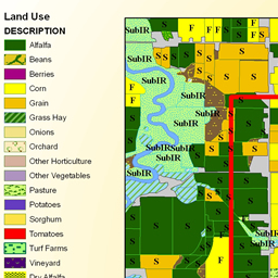
As part of developing and updating the State Water Plan, the Utah Division of Water Resources collects water-related land use data for the entire state. This data includes the types and extent of irrigated crops as well as information concerning phreatophytes, wet/open water areas, dry land agriculture and residential/industrial areas.
The data produced by the water-related land use program are used for various planning purposes. Some of these include: determining cropland water use, evaluating irrigated land losses and conversion to urban uses, planning for new water development, estimating irrigated acreages for any area, and developing water budgets. Additionally, the data are utilized by many other state and federal agencies. Water-related land use can be used to depict Irrigation type (Irrigated, Sub-Irrigated, Non-Irrigated, Riparian, Urban, etc).
See the accompanying FGDC metadata for description of extensive Land Use, Irrigation Type, and Vegetation Cover codes. There are no constraints or warranties with regard to the use of this dataset.
Comments, questions, compliments, or concerns can be directed to Thomas Moore from DNR at tmoore@utah.gov.
Related Resources
Downloads and Web Services
Updates
SurveyYearcontains currency information