Public Safety
- Category: Society
- Data Type: GIS Data Layer
- Steward(s): UGRC
- Abstract: This section has four groups of data relating to public safety in Utah. Public safety facilities and boundaries (where appropriate) are included for correctional, fire, law enforcement, and dispatch activities.
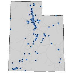
Correctional Facilities

Correctional Facilities contains locations for jails and prisons in Utah. A jail or prison defined by the Department of Justice consists of any facility or location where individuals are regularly and lawfully detained against their will. This includes Federal and State prisons, local jails, and juvenile detention facilities, as well as law enforcement temporary holding facilities. Locations which function primarily as law enforcement offices are included in this dataset if they have holding cells.
There are no constraints or warranties with regard to the use of this dataset.
Comments, questions, compliments, or concerns can be directed to the staff from UGRC at ugrc@utah.gov or 801-538-3665.
Downloads and Web Services
Updates
- June 2013
- August 2011
Fire Stations

Fire Stations includes any location where fire fighters are stationed or based out of, or where fire fighting equipment is stored. This definition includes fire stations that are both private and public entities, and fire stations that primarily fight forest or grassland fires. Fire fighting training academies are also included.
Comments, questions, compliments, or concerns can be directed to the staff from UGRC at ugrc@utah.gov or 801-538-3665.
Downloads and Web Services
Updates
- October 2020 - Updates to Weber County fire stations
- June 2013
- August 2011
Law Enforcement Facilities

Law Enforcement Facilities contains locations in Utah where sworn officers of a law enforcement agency are regularly based or stationed. Law enforcement facilities are at least partially publicly funded. This law enforcement dataset includes federal, state, local and special jurisdiction facilities. Examples of law enforcement facilities included are municipal police, county sheriffs, state police, school police, park police, railroad police, and federal police.
Comments, questions, compliments, or concerns can be directed to the staff from UGRC at ugrc@utah.gov or 801-538-3665.
Downloads and Web Services
Updates
- June 2013
- August 2011
Law Enforcement Boundaries

Law Enforcement Boundaries contains jurisdictional boundaries for law enforcement agencies in Utah. Law enforcement boundaries indicate which law enforcement agency has the primary responsibility in a specific area. These boundaries are also used in the Next-Generation 911 system for recommending which agency should respond to a specific location.
Comments, questions, compliments, or concerns can be directed to the staff from UGRC at ugrc@utah.gov or 801-538-3665.
Downloads and Web Services
Updates
- February 16, 2022 - Updates based on recent municipal annexations
- December 13, 2021 - Updates based on recent municipal annexations
- November 9, 2021 - Updates based on recent municipal annexations
- August 10, 2021 - Added Taylorsville PD and made updates based on recent municipal annexations
- July 21, 2021 - Updates based on recent municipal annexations
- June 16, 2021 - Removed Monticello PD
- June 1, 2021 - Added Riverton PD
- March 11, 2021 - Updates for initial NG911 submission
PSAP Locations

PSAP Locations represents the primary Public Safety Answering Point (PSAP) locations in Utah. The Salt Lake County Sheriff Office PSAP is secondary. The original dataset was created in December 2004 by geocoding the PSAP addresses provided by the E911 Executive Committee.
Comments, questions, compliments, or concerns can be directed to the staff from UGRC at ugrc@utah.gov or 801-538-3665.
Downloads and Web Services
Updates
- June 28, 2021 - Updated PSAP phone numbers
- March 11, 2021 - Updates for initial NG911 submission; matched names to PSAP Boundaries layer
- January 28, 2020 - Updated name of Central Utah 911
- December 10, 2018
- November 25, 2013
PSAP Boundaries

PSAP Boundaries represents Public Safety Answering Point (PSAP) boundaries in Utah that will be used for call-routing in the Next-Generation 911 system. PSAP jurisdictions related to county and municipal boundaries are based on the boundaries that were current on the date the data were last updated. The data also includes jurisdictional boundary representations of the Navajo Nation Tribal Lands, Hill Air Force Base, and Colorado City.
Comments, questions, compliments, or concerns can be directed to the staff from UGRC at ugrc@utah.gov or 801-538-3665.
Downloads and Web Services
Updates
- January 6, 2022 - Updates based on recent municipal annexations
- December 13, 2021 - Updates based on recent municipal annexations
- November 9, 2021 - Removed Navajo Nation PSAP and updates based on recent municipal annexations
- July 21, 2021 - Updates based on recent municipal annexations
- June 23, 2021 - Updated PSAP phone numbers
- March 11, 2021 - Updates for initial NG911 submission. Several adjustments made based on inputs from PSAP managers. Rebuilt data to align with current county and municipal boundaries.
- November 12, 2020 - Updates based on recent municipal annexations, corrections for Washington County, and Weber County/Hill AFB.
- January 28, 2020 - Added Centerville to Bountiful PD jurisdiction. Adjusted municipality-centric boundaries to account for recent annexations. Updated name of Central Utah 911.
- January 4, 2019
State Agency Dispatch

State Agency Dispatch represents State of Utah dispatch center boundaries.
Comments, questions, compliments, or concerns can be directed to the staff from UGRC at ugrc@utah.gov or 801-538-3665.
Downloads and Web Services
Updates
- October 2013