Roads and Highway System
- Category: Transportation
- Data Type: GIS Data Layer
- Steward(s): UGRC, Local Government partners
- Abstract: This dataset contains GIS mapping data representing the statewide roads centerline dataset for Utah and other road and highway related data such as milepost locations, exit numbers and names, polylineM highway linear referencing system (LRS) routes, and label lines for dynamic rendering of highway shields.
Road Centerlines

Transportation.Roads is a multi-purpose statewide roads dataset for cartography, routing, and range based-address location. This dataset is also used as the base geometry for deriving the GIS-representation of UDOT’s highway linear referencing system (LRS) as well as UGRC's network analysis datasets.
This layer also plays an important role in active transportation planning in Utah. Recent collaborative efforts between UGRC, UDOT, and WFRC have led to significant enhancements in the bike and pedestrian data in both the Roads and Trails-and-Pathways layers. These efforts have focused on better connectivity between the layers (along the Wasatch Front), as well as improvements in the statewide bike data. You can contribute to the on-street bike data by letting us know where we have gaps or inaccurate information.
Transportation.Roads utilizes a data model based on Next-Generation 911 standards and the Federal Highway Administration's All Roads Network Of Linear-referenced Data (ARNOLD) reporting requirements for state DOTs. UGRC adopted this data model on September 13th, 2017.
To see specific information about the data model including field names and descriptions, data types, coded value
domains, and data model updates, see the data
model spreadsheet and the corresponding tabs for update notes and coded value domains. The color-coded
section titled Addressing is primarily maintained by the local stewards, where as the section titled
DOT/FHWA is primarily maintained by UDOT. UGRC spatially assigns fields in the section titled
Placename/Area, based on current SGID polygon boundaries. UGRC also generates the
UNIQUE_ID field based on the segment's location in the US National Grid, with the street name then
tacked on. The UNIQUE_ID field is static and is UGRC's current, ad hoc solution to a persistent
global id.
This data model is meant to suggest 'best practices'. It is not the intent that all stewards will change their current data management process to match this standard, but rather that stewards will evaluate their current practices to see how well their data 'maps' to this schema for data sharing and Next Generation 911 preparedness.
Comments, questions, compliments, or concerns can be directed to Greg Bunce from UGRC at GBunce@utah.gov or 801-349-0039.
We are currently working with US Forest Service to improve the Forest Service roads in this dataset, however, for the most current and complete set of USFS roads, please visit the FSGeodata Clearinghouse.
The native spatial reference for this dataset is UTM Zone 12N, NAD83 (0.01 meter coordinate precision). The statewide roads dataset is maintained by UGRC in partnership with local government, the Utah 911 Committee, and UDOT.
Related Resources
Downloads and Web Services
Updates
Updates to this dataset are published every month, with approximately nine counties receiving detailed review.
Highway Linear Referencing System Routes

The UDOT Routes ALRS layer is a polylineM dataset wherein each state and federal route is a single feature whose vertices include a milepoint measure coordinate.
Major routes (shown in the ROUTE_ID field) are named using UDOT’s naming convention (ex. 0089PM is
US-89, a mainline route in the positive direction). Ramps and collectors are also included and have 11 character
identifiers (ex. 0015NR31703 is at exit 317 on I-15).
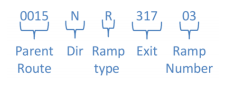
ROUTE_ID field codes:
Prepresents Positive direction (increasing milepoint values)Nrepresents Negative direction (for divided routes only)Mrepresents MainlineRrepresents RampCrepresents CollectorXrepresents Other
The native spatial reference for this dataset is UTM Zone 12N, NAD83. The GIS dataset representing the UDOT ALRS is stewarded by UDOT with assistance from DTS, UGRC and local government.
The CARTO_CODE field can be used to query subsets or classify different types of UDOT routes:
- 1 - Interstate highways
- 2 - US highways
- 3 - State highways
- 5 - Miscellaneous routes associated with interchanges
- 6 - Ramps, Interstates
- 7 - Ramps, US Highways
- 8 - Ramps, State highways
- 9 - Local routes, federal aid
- I - Institutional roads designated as state highways
Related Resource
Downloads and Web Services
Updates
- Updates to this dataset are published periodically to refine route representation, add additional routes, and in response to route realignment.
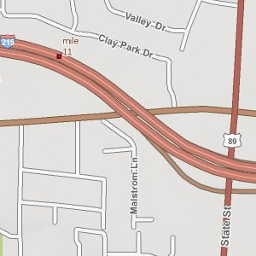
Mile Reference Posts

The Mile Reference Posts dataset contains the location of milepost signs as they are located along the roads. This collection technique is different from milepost locations that are derived from a linear reference system (LRS). The advantage of this collection method is that the mile reference posts stay in roughly the same place over time and do not change when other sections of the road, or LRS, are realigned.
Mile reference post locations are derived from images captured by Mandli Communications, using on-the-ground asset collection technology. These locations were then aligned to UDOT’s linear referencing system.
This data will be updated through on-the-ground collection every 2 years under the current contract. The data served on this page was captured in 2021 and reflects what was on the ground at that time.
The Mile Reference Posts is an ESRI Roads and Highways Event layer and supports the RP Stationing App.
FIELDS worth noting
Legend- Milepost number on signMeasure- Location of the milepost along the LRSStation Label- Highway name + direction of route along LRS (P = positive, milepost numbers increasing; N = negative, milepost numbers decreasing) + milepost number. For example the value 0015PM_271 translates to mile marker 217 on Interstate-15 on the north bound (P) side.
Mile Reference Posts vs Linear Measures
Mile Reference Posts are signs located in physical locations. They are helpful for navigation but may not reflect the linear referencing measurement.
Linear referencing system mile point measures (linear measures) are calculated based on geometric lengths of data and are spatially accurate. They may or may not align with actual Mile Reference Posts and are updated every time a change is made in the spatial data to reflect updates in the physical location and length of the roadway.
For more information on the difference between mile reference posts and linear measures, please refer to UDOT’s webpage addressing this topic or their informational document.
Related Resource
- Linear-measure based mileposts (derived from UDOT’s linear referencing system and contains tenth-mile points)
- UGRC Milepost and Reverse Milepost Geocoding Web API
- UDOT Mile Reference Post Stationing Application (RP Stationing App)
Downloads and Web Services
Updates
- 2021
Freeway Exit Points

Transportation.Roads_FreewayExits contains point locations for each freeway and limited access highway exit along with the exit number, name, associated route, and connected streets/routes.
The EXITNAME field provides the primary route name and exit number plus the connecting route number or street name and place name carried by the exit sign. Route number and exit number are also carried in separate fields.
The native spatial reference for this dataset is UTM Zone 12N, NAD83 (0.01 meter coordinate precision). This dataset was assembled by UGRC from resources provided by UDOT, as a resource for 911 dispatch and for general map reference.
Downloads and Web Services
Updates
- Updates to this dataset are published infrequently.
Shield Labeling Lines

Transportation.RoadsShieldLines consists of highway route lines edited to best enable non-redundant, dynamic label rendering of highway shields for freeways, US highways, and state highways.
In ArcMap, define a label class for each CLASS field value. 1 is for freeways, 2 for US highways, and 3 is for state highways. Each label class should use a SQL expression to define the class and the default class should be disabled or deleted.
When defined labeling properties are defined properly, the minimum number of freeway and highway shields should be displayed without introducing ambiguity.
The native spatial reference for this dataset is UTM Zone 12N, NAD83 (0.01 meter coordinate precision). This dataset was assembled by UGRC for general purpose cartography.
Downloads and Web Services
Updates
- Updates to this dataset are published infrequently.