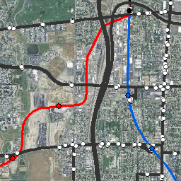
Bus, Commuter, and Light Rail
- Category: Transportation
- Data Type: GIS Data Layer
- Steward(s): Utah Transit Authority (UTA)
- Abstract: This dataset contains the UTA bus routes and stop locations, commuter rail (FrontRunner) route and stop locations, and light rail (TRAX) route and stop locations.
UTA Routes & Most Recent Ridership

Feature Layer includes all Utah Transit Authority routes for bus, Light Rail (TRAX), and Commuter Rail (Frontrunner). Includes: Route Number (UTA's short name), route name, frequency in minutes, route type, average weekday ridership, and all cities and counties the route services.
Routes are updated 3 times a year (typically April, August, and December). Weekday ridership values (AvgBrd) are updated monthly.
The most recent average weekday boarding is updated monthly after the 10th of the following month.
Comments, questions, compliments, or concerns can be directed to Sumerset Ellis from UTA at SEllis@rideuta.com.
Downloads and Web Services
Updates
- February, 2021
UTA Stops & Most Recent Ridership
Feature Layer includes all Utah Transit Authority stops for bus, Light Rail (TRAX) and Commuter Rail (FrontRunner). Includes: Stop Name, City, Zip Code, County, Routes served, Stop Number (Integer), Stop Abbreviation (Text), Mode (Bus or Rail), Average Weekday Boarding and Alightings, and the Latitude and Longitude of the stop.
Stop locations are updated 3 times a year (typically April, August, and December). Weekday ridership values (AVGBoard, AVGAlight) are updated monthly.
Stop Number (UTA_StopID) represents the numeric stop numbers.
Stop Abbreviation (StopAbbr_J) describes the type of stop:
- All numeric values
- A regular bus stop.
- Beginning with BB
- A bus bay
- Beginning with FR
- A FrontRunner station
- Beginning with S
- Ski resort access stop
- Beginning with TX
- A TRAX station
Average weekday boardings and alightings are updated monthly after the 10th of the following month.
Comments, questions, compliments, or concerns can be directed to Sumerset Ellis from UTA at SEllis@rideuta.com.
Downloads and Web Services
Updates
- January, 2021
UTA Commuter Rail Routes

Utah Transit Authority’s Commuter Rail (FrontRunner) Routes. This Feature Layer includes FrontRunner North and South centerline.
Comments, questions, compliments, or concerns can be directed to Sumerset Ellis from UTA at SEllis@rideuta.com.
Downloads and Web Services
Updates
- May, 2013
UTA Commuter Rail Stations

Utah UTA Commuter Rail Stations depict the locations of Utah Transit Authority's FrontRunner North and South commuter rail stations as received from UTA.
These data include an attribute of the address where the rail station is located.
Comments, questions, compliments, or concerns can be directed to Sumerset Ellis from UTA at SEllis@rideuta.com.
Downloads and Web Services
Updates
- May, 2013
UTA Light Rail Routes

Utah UTA Light Rail Routes represent the light rail system for the main North-South (Downtown to Sandy), University/Medical Center, West Valley, Daybreak, and Airport lines. It also depicts the Sugar House trolley extension currently under construction.
UTA Light Rail Routes was digitized from aerial photographs dated August, 2016.
The native spatial reference for this dataset is UTM Zone 12N, NAD83 (0.01 coordinate precision).
Comments, questions, compliments, or concerns can be directed to Sumerset Ellis from UTA at SEllis@rideuta.com.
Downloads and Web Services
Updates
- January, 2017
UTA Light Rail Stations

Utah Transit Authority’s Light Rail (TRAX) Stations. Point represents the center of the platform. Includes address, station name, TRAX routes served and whether or not station has a Park and Ride.
Comments, questions, compliments, or concerns can be directed to Sumerset Ellis from UTA at SEllis@rideuta.com.
Downloads and Web Services
Updates
- May 12, 2013