Discover Server Resources and Information
Discover Server
Discover provides high-performance imagery and base maps services in WMS and WMTS formats. For information about the services and directions to sign up, please see the main Discover page.
- For imagery downloads visit the aerial photography data page.
- Instructions on how to use the Discover services in Pro/ArcMap.
- Instructions on how to use the Discover services in CAD.
- Instructions on how to use the Discover services in Web Maps.
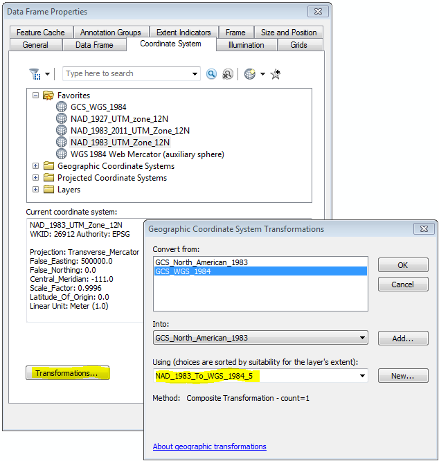
Coordinate System and Datum
The native coordinate system for the Discover services is Web Mercator with a WGS 1984 datum (EPSG 3857). Many users work in coordinate systems with a different datum (for example, EPSG 3566: Utah Central with NAD 1983). Users who need the highest locational precision must use the appropriate geographic transformation conversion to remedy the roughly one meter difference between the WGS84 and NAD83 datums’ “realization points.” UGRC uses the NAD_1983_To_WGS_1984_5 transformation when creating base map tiles and web applications, but there may be more accurate transformations based on the data and area you are working with. The default (no transformation specified) will likely introduce several feet of horizontal positional error. More information about these transformations can be found on ESRI’s NAD 1983 To WGS 1984 How-To.
ArcGIS Pro seems to load an appropriate transformation, but you may need to set the transformation in ArcMap or other software.
Horizontal Positional Accuracy
Stated horizontal accuracy of the Google imagery is expected to achieve or exceed one meter (CE90) in most areas without significant vertical relief. You can generally expect higher precision in urban areas where existing supplemental ground control was more abundant.
The 15cm and 30cm Hexagon imagery have stated horizontal accuracies of 1.07 and 2.6 meters (CE90), respectively.
The pre-2018 NAIP layers have a stated horizontal positional accuracy of 5 meters, while the 2018 NAIP products have a horizontal positional accuracy of 4 meters.
Adding a WMTS or WMS Service to ESRI Products
ArcGIS Pro 2.x:
Insert -> Connections -> New WMTS Server- Paste the
WMTSlink you have been provided into theServer URL:line and clickOK - Navigate to the newly added
utah imagery - WMTS on discover.agrc.utah.gov.wmtsconnection underServersin the Catalog window. - Expand the nodes until you see a list of all of the imagery and base map services that are available to your login. The full list can be viewed on the main Discover page.
- Add your desired service to your map like you would any other layer.
ArcMap 10.x
Add Data, selectGIS Serverfrom theLook in:dropdown list, and double-clickAdd WMTS server- Paste the
WMTSlink you have been provided into theURL:line and clickOK(don’t worry about Parameters, Server Layers, or Username/Password) -
Navigate to the newly added
utah imagery – WMTS on discover.agrc.utah.govconnection and double click to connect.- You can rename the connection after it has been added
- Expand the nodes until you see a list of all of the imagery and base map services that are available to your login. The list can be viewed on the main Discover page.
- Add your desired service to your map like you would any other layer.
Adding a WMTS or WMS Service to a Web Map
Interested in using UGRC’s Web Mercator services in your web maps? Take a look at this page for more information. Remember, if the web map is going to be public facing you need to request a separate quad-work link. To do this send an email to Jake Adams from UGRC at jdadams@utah.gov and provide your web map URL domains.
Adding a WMS Service to CAD
- Bentley Microstation users should take a look at the How To document.
- AutoCAD Civil 3D users should take a look at the How To document.
Adding a WMTS Service to QGIS
- Add a new “WMS/WMTS” connection and paste in the URL to the discover WMTS service.
Read this blog post for more details.
Printing Web Maps with Discover Services
Take a look at this blog post for information about Printing Web Maps with Discover Services.
Google Archive Services
In addition to the statewide Google imagery service layer, there are archive layers available (ex. Google 2011archive) of the Google imagery organized by year collected.
Licensed Imagery Flight Dates
The flight dates of each Hexagon imagery flight line are in the opensgid.indices.hexagon_service_dates SGID layer. This layer is also available on our Open Data site, where you can get a link to the web service or download it in the format of your choice.
Similarly, the dates of the ‘Google’ imagery service layer are stored in the opensgid.indices.google_service_dates SGID layer available on our Open Data site.
Pro/ArcMap User Considerations
Legacy username/password users: If you have not yet received quad-word links to the service (ex. https://discover.agrc.utah.gov/login/path/your-unique-quad-word/) that do not require a username and password, please contact Jake Adams from UGRC at jdadams@utah.gov.
Users experiencing problems with the service, such as blurry tiles or different year vintages at different scales, may need to clear their local cache:
-
ArcMap Go to the service’s
Layer Properties -> Cachetab and selectingClear Local Cache Now. Be patient as this could take several minutes. If the blurry tiles persist you have the options toClear cache when the session endsorDon't cache any data locally. Another option is to completely clear your ArcMap cache by going toCustomize -> ArcMap Options -> Display Cache -> Clear Cache. -
ArcGIS Pro Go to the service’s
Layer Properties -> Cachetab and selectingClear Cache. You can also clear your entire Pro cache by going to the Pro project’sOptions -> Displayand checkClear cacheand selectingOK.
ArcMap 10 and 10.1 users should use WMS instead of WMTS. ArcMap 10 and below do not support WMTS, and ArcMap 10.1 has issues rendering WMTS data.
Usage Tracking
Individual organizations will be provided URL links for the Discover services that are unique to their organization. This will allow us to track general usage metrics and monitor the performance of the services. Do not distribute your URL links outside of your organization or division.
Citation and Logos
As part of our licenses with Google and Hexagon, you must provide proper attribution of any products created with their imagery.
-
Hexagon requires the following attribution on any products made using the Hexagon imagery (15/30cm imagery 2018 and later):
- Print: “© 2020 HxGN Content Program, Hexagon”, with the year being the first year you published the product.
- Online: “© 2020 HxGN Content Program, Hexagon”, with the year being the first year you published the product and the text
HxGN Content Programlinking to https://hxgncontent.com
-
Google requires you to put the appropriate logo (zipfile) on any products made using the Google imagery (6” imagery earlier than 2018):


For products that use the UGRC-produced basemaps, please include a short attribution that complies with the main UGRC Data License and Disclaimer guidelines.
Requests for On-Premise Use
You may request a local copy of the NAIP, HRO, Hexagon, and Google imagery for off-line consumption when the provided imagery service does not meet your needs. Please provide the following information to Jake Adams from UGRC at jdadams@utah.gov for consideration:
- Name & organization
- Reason for request
- Working on behalf of (for licensed Hexagon/Google imagery)
- Project names
- Project locations
Layers Not Exporting When Using WMS
If you are using a WMS connection, you may find that the Discover layer does not show up when you export or print your map. This is due to a technical limitation of the WMS protocol. The only fixes are to use WMTS, export at a lower resolution, or use a local copy (for aerial imagery).
Background
In WMS, the client (ArcMap, a browser, etc) requests a map of a specific extent and resolution. The server creates a single image matching the request and returns it to the client—a 8.5” x 11” image at 100 dpi would be 850 x 1,100 pixels (just shy of one megapixel). Every time the user pans or zooms, the server creates and sends a completely new image, which consumes server processing power and bandwidth. To maintain performance for all users, WMS servers will not create and return an image if its dimensions exceed a certain size.
Applications like ArcMap and web browsers have a relatively small window and use a resolution of 96 dpi, resulting in requests that fit within the server’s allowed size. However, exporting a 20” x 30” map at 300 dpi results in a 6,000 x 9,000 pixel (54 megapixel) image. This far exceeds the server’s limit, so it does not return an image. ArcMap dutifully finishes exporting the map instead of raising an error, resulting in a map without the layer. You can try changing the Output Image Quality (Resample Ratio) setting to reduce the requested resolution, but the output quality will suffer.
In contrast, WMTS works by delivering a set of fixed-dimension tiles at the requested zoom level that cover the requested extent. Because the tiles are pre-rendered, all the server has to do is figure out which tiles to send and then send them—and this is sped up by the client caching previously received tiles and only requesting ones it hasn’t seen yet. This allows WMTS to quickly serve up tiles for much larger and/or more detailed maps than WMS without clogging the server.
Small Text/Symbology in QGIS
When using the basemap services in QGIS, you may experience small text and symbology when using bilinear or cubic resampling at scales other than the normal web map scales. The resampling settings are defined in Layer Properties > Symbology > Resampling. Using bilinear or cubic resampling can look much better than the default nearest neighbor method.
This behavior is controlled by the “oversampling” value. At values greater than 1.00, the text/symbology can appear smaller (QGIS is sending a “zoomed out” WMTS request and sampling it down to your desired scale). At values less than 1.00, text/symbology can appear larger (it sends a “zoomed in” request and samples it up). QGIS uses the resampling method selected in the “in” dropdown at values less than 1.00, and the “out” method at values greater than 1.00.
Other Tidbits
- We suggest that you occasionally refresh the connection to the imagery services by right-clicking your service connection in ArcCatalog or ArcMap’s Catalog Viewer and selecting the
Refreshbutton to see the latest list of available services. - Since the Google acquisition flight blocks are not done all at once (as opposed to the NAIP products, which cover the whole state for every acquisition), there will be distinct color and positional changes at flight block boundaries. For large area maps, the color-balanced NAIP may be a more aesthetically pleasing cartographic choice.
- UGRC has downloaded a statewide master set of the image files for redistribution, as the download process directly from the Google Cloud Platform incurs transactional costs for cloud server & bandwidth usage.
- UGRC has a feedback reporting form for imagery users around the state to report imagery and service issues so they can be passed along to the imagery producers. Please submit your feedback through this form.