Sharing GIS Data
In This Section
| Sharing with the SGID Index | Sharing with the SGID Open Data site | Sharing with Open SGID | Basic Metadata Creation Process | Sharing Highlights |
The SGID: A Community Effort
The Utah State Geographic Information Database (SGID) is one of the premier statewide GIS data resources in the country, providing clean, consistent, and authoritative data across every geography in the state. People have been turning to the SGID for nearly 30 years to support their personal, commercial, academic, and government projects.
Nearly all the data that make the SGID such a valuable resource come from cities, counties, and other state agencies. We offer a heartfelt Thank You! on behalf of both UGRC and all the users of the SGID to everyone who has contributed data.
We hope you’ll follow the example of our current contributors and consider sharing your data with a broad audience through the SGID. We have three separate “tracks” to follow based on where your data fit best: the SGID Index, the SGID Open Data Site, or the Open SGID. There’s also a separate process for contributing to or updating an existing SGID dataset.
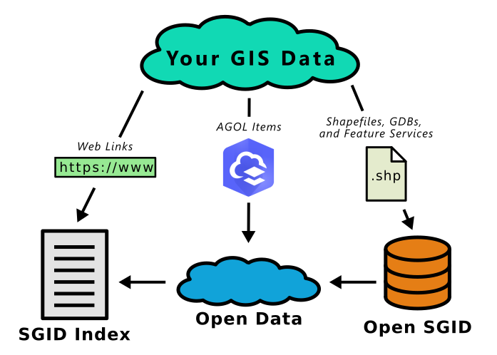 Note: This data flow works for 95% of datasets, but exceptions can and do exist.
SGID Index
The simplest way to share your data is by adding links for existing, qualifying data (what we call “external data”) to the SGID Index, which aims to be a database of all statewide GIS resources. If you are hosting GIS resources on your own server, we can link to your datasets in the SGID Index and in the category pages on our website. The category pages help people discover related datasets by grouping data together by topic.
Click here to start sharing your hosted data with the SGID Index.
SGID Open Data Site
We use Esri’s open data offering to maintain the SGID Open Data site (opendata.gis.utah.gov), a central list of ArcGIS Online and ArcGIS Enterprise Portal services. This is a great way to use your existing ArcGIS Online or Enterprise infrastructure to share your data with little additional work. We are happy to include any datasets in the SGID Open Data site that meet our qualifications. Just like the SGID Index, AGOL items hosted in your organization are considered “external data.”
Click here to start sharing your AGOL items with the SGID Open Data site.
Open SGID
The Open SGID is a curated, publicly-accessible database of statewide GIS layers—the latest evolution of the traditional “SGID as a single geospatial database” model. We are excited to offer a direct connection to everyone once again.
If you have a statewide dataset but don’t have the ability to host or share it yourself, we may host it in the Open SGID if it meets our qualifications. We also share most Open SGID layers through opendata.gis.utah.gov (by first uploading it as a feature service in our ArcGIS Online organization). Unsurprisingly, we refer to these datasets as “hosted data.”
Maintaining data in the Open SGID requires the most work, both on the front end and for long-term maintenance. We encourage you to share your data via SGID Open Data or the SGID Index whenever possible. However, in order to maintain consistency and familiarity with previous versions of the SGID geodatabase, we may include some datasets in the Open SGID that are otherwise better suited for SGID Open Data or the SGID Index. This is done at our discretion according to our policies.
Click here to share your data with us for inclusion in the Open SGID.
Contributing to an Existing SGID Dataset
If you are the local authoritative source for existing hosted data, we’d love to work with you to pull your latest data into the SGID. Many of our most popular datasets are the result of collaboration with cities and counties. We will evaluate independent, crowd-sourced or commercial contributions on a case-by-case basis to make sure they are authoritative and not substantially restricted.
To contribute to an existing dataset, please use the contact info listed on the dataset’s data page.