What to know about GIS in Utah
As Utah’s map technology coordination office, the Utah Geospatial Resource Center (UGRC) provides a wide range of GIS and other geospatial support services, including providing training on Utah GIS. As part of that educational role, UGRC has developed this document to provide links to relevant Utah GIS websites and information. View the printable PDF version of this guide.
General UGRC Resources
- UGRC: The UGRC website is Utah’s GIS data clearinghouse.
- Open SGID: The Open SGID is a publicly available PostGIS database containing State Geographic Information Database (SGID) (i.e., all Utah vector data).
- Open Data: UGRC’s Open Data site is the SGID served as ArcGIS Online feature services.
- Raster Discovery Application: UGRC’s Raster Discovery Application allows users to search and download aerial photography, elevation data, and USGS topographic maps for a user-defined area of interest.
UGRC’s Discover Imagery and Base Map Server Resources
- UGRC’s Base Map and Imagery Services: Discover provides imagery and base maps services in Open Geospatial Consortium (OGC) standard Web Map Tile Service (WMTS) and Web Map Service (WMS) in the Web Mercator WGS84 projection (wkid: 3857). This page provides general background information on Discover and explains how to sign up for access to Discover.
- Discover Server Resources and Information: Once users have signed up for Discover, they can check out this page to learn everything there is to know about consuming the services available from Discover.
Training
Online Esri Training
Esri has many online courses that are included in the annual software maintenance cost. They also have several basic free courses that are a good introduction to GIS and ArcMap/ ArcGIS Pro.
Free Esri Courses
- Intro to GIS
- GIS Basics (ArcGIS Pro)
- Getting Started with GIS (ArcMap)
- Getting Started with ArcGIS Pro (Intro ArcGIS Pro)
- Cartography MOOC (This is a great introduction to cartographic design principles and applications.)
- AGOL Fundamentals (This includes short intro videos; one intro course; and several advanced, maintenance required courses.)
AGOL Basics and Essentials
- Esri’s getting started page
- *Credit usage by capability
- Credits can be purchased in blocks of 1,000, usually for $100 (i.e., 10 cents/credit).
- AGOL subscription types and pricing
- AGOL user account control: types, roles, and privileges

Public Land Survey System at a Glance


Distance Conversions
- 1 Mile
- = 80 chains
- = 320 rods
- = 320 perches
- = 320 poles
- = 5,280 feet
- = 8,000 links
- = 1,609.2655 meters
- 1 Chain
- = 4 rods
- = 4 perches
- = 4 poles
- = 66 feet
- = 100 links
- = 20.1168 meters
- 1 inch
- = 0.0254 meters
- 1 Link
- = 0.66 feet
- = 7.92 inches
- = 0.2017 meters
- 1 Meter
- = 39.370 inches
- = 3.281 feet
- 1 Rod
- = 16.5 feet
- 1 Perch
- = 25 links
- 1 Pole
- = 5.0292 meters
- 1 Foot
- = 0.3048 meters
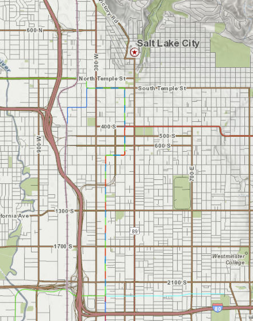
Example Description: A parcel of land situated in the south half of the southeast quarter of the northeast quarter of Section 31, Township 2 South, Range 2 West, Salt Lake Base and Meridian.
Geographic Coordinate Data Base (GCDB) Point IDs
Area Conversions
- 1 Sq. Mile
- = Nominal Section
- = 640 acres
- = 2.590 sq. km.
- = 259 hectares
- 1 Acre
- = 10 sq. chains
- = 160 sq. rods
- = 160 perches
- = 160 poles
- = 43,560 sq. feet
- = 0.4047 hectare
- = 4,047 sq. meters
- 1 Hectare
- = 2.47 acres
- 1 Sq. Meter
- = 10.764 sq. ft.
XxxYyy, where Xxx = the following range of values
- 711 - 719 Town Sites, City Boundaries
- 720 - 739 County Boundaries
- 740 - 769 State Boundaries
- 770 - 799 Forest Service, Parks Service, Reservations,
- Grant, Other Boundaries with Mileposts.
- 800 - 836 Meanders (right bank even #, left bank odd #.)
- 837 - 879 Tracts
- 880 - 899 Right of Ways
- 900 - 999 Mineral Surveys, Homestead Entries, etc.
Yyy - Numbered sequentially along the survey in increments of 10. The prefix
Xxx - may be the same for all points in a similar survey.
Irregularities of Townships for ones places of Xxx and Yyy.
1, 2, 8 or 9 -> offset corners along interior section lines and section subdivision lines where +/- 2 is the recommended naming scheme and THE GRAPGICS RULE MUST BE FOLLOWED.
3 or 7 -> offset corners along township boundaries, angle points, witness corners, and witness points.
4 or 6 -> intersections of rectangular/special surveys and 1/16th corners of elongated sections.
0 -> all regular aliquot corners down to 1/16th.
5 -> all regular aliquot corners down to 1/256th.


Township and Range
(5 characters each)
- 3 digits for Township or Range number
- 1 digit for fraction (0 for no fraction, 1 for 1/4 township, 2 for 1/2 township, 3 for 3/4 township)
- 1 letter for direction